|
|
Sunday drive : Lebanon-Israel borderPosted by finkployd in
Info 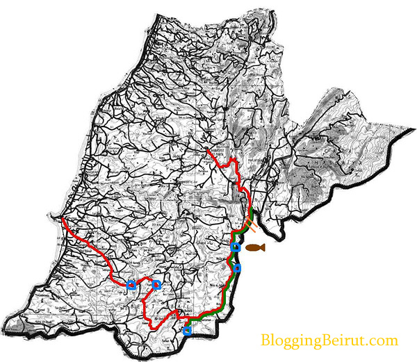 high res -- Legend -- Red: route taken Green: route along which tank tracks had visibly cut into the surface of the road Blue: United Nations presence. The two western-most circles were recently deployed troops. The southerly position and the two easterly ones are permanent UN observation points. Troops were seen at the most north eastern of these locations, but not at the other two. Orange marks: points where heavy vehicles (presumably Israeli armour) appeared to have crossed the border. The border fence had been torn down and is mended haphazardly. No Israeli military were now visible. Brown blimp: approximate location of a dirgible flying above Israel and attached to the earth by cable. Local Lebanese said that this is an Israeli surveillance device. -finkployd - all rights reserved Trackbacks
Trackback specific URI for this entry
No Trackbacks
comments powered by Disqus Comments
Display comments as
(Linear | Threaded)
The Dutch minister of forein affairs, mister Ben Bot, has started a round trip between Palestine, Israel, and Libanon. The Dutch cabinet will donate 5 million euro extra for help, 3 million euro for Palestine and 2 million euro for Libanon. The Dutch minister was yesterday in Palestine, and has spoken with the Palestine prime minister. Today the Dutch minister wil speak with the Israeli's , and will ask attention for the Palestine prisonners. Tomorrow, or the day after, the Dutch minister will speak with the Libanese prime mister to inform in what way the Dutch cabinet can help. The Dutch cabinet dont want to sent troops, but, if needed and welcome, they want to sent logistic help to aid rebuilding en distrubution of help goods in the the country. The Dutch minister has started this roundtrip, because the Dutch cabinet wanted to show his concernement with the region.
"When a man takes a farm from which another has been evicted you must shun him on the roadside when you meet him, you must shun him in the streets of the town, you must shun him in the shop, you must shun him in the fairgreen and in the marketplace, and even in the place of worship, by leaving him alone, by putting him in a moral Coventry, by isolating him from the rest of his country as if he were the leper of old, you must show your detestation of the crime he has committed."
These words were spoken by Parnell a great Irish guy The case holds true be it lands which belong to Palestinians or Lebanese He also said a.- "No man shall have a right to fix the boundary to the march of a nation ," Try telling this to Bush etc and all who seek to tell small lands to accept their lot as dictated by Bush etc .. Can you see USA or UK being happy at having land stolen or spied upon with a view to doing such . ? I most certainly cannot . As long as the powers keep doing this to Lebanon and to Palestine there will of course be resistance .. Yes I am using the right word too It is resistance . By the way on a more sinister note i want you folks to know that Blair and Bush are really evil . Their smoke screen etc is working . I have been informed by a friend in UK today of the following . Last week a plane full of passengers ( Monarch airlines ) could not take off from Costa del sol to Manchester . Reason ? The passengers ... Mainly low level educated Brits refused to allow it until two Arabic men had been removed . Seems their converstaion in their own language caused anxiety Ahhh shame lol But the outrage is These 2 men were removed !!!!!!! This is how hatred begins and Blairs smoke screens plus those of Bush are working all too well with the masses . We have much work to do to reach to uneducated masses
More evidence that Israel is lying:
"Human Rights Watch found no cases in which Hezbollah deliberately used civilians as shields to protect them from retaliatory IDF attack." After investigating a handful of cases, Human Rights Watch found that in "none of the cases of civilian deaths documented in this report [Qana, Srifa, Tyre, and southern Beirut] is there evidence to suggest that Hezbollah forces or weapons were in or near the area that the IDF targeted during or just prior to the attack."
Where did u get this information... I would like to access it if possible please.
http://www.hrw.org/english/docs/2006/08/03/lebano13910.htm
Report that states no civilians used as sheilds
I thought you might want to know Associated Press currently have a picture of the observation zeppelin/blimp/dirigible near Kiryat Shmona / Metulla that you mention in this post. Might be worth adding to one of your posts, for documentation purposes. :-)
Here's a shortened url to the link. I think they have some sort of rotating scheme with respect to their photos, so this might change very soon. It's up there now though. http://tinyurl.com/q4zgb |